
All of the world’s shallow coral reefs have been digitally mapped, thanks to a three-year project combining two million satellite images, enormous amounts of field data and University of Queensland-developed mapping techniques.
The Allen Coral Atlas project has officially launched its high-resolution maps of the world’s reefs which, together with the Atlas’s coral monitoring tool launched in May, will revolutionise reef management.
The project is an international research collaboration led by Arizona State University in partnership with UQ, Planet Ltd, National Geographic and Vulcan Inc.
UQ’s Remote Sensing Research Centre researcher Dr Chris Roelfsema said the digital atlas is a comprehensive and continually updated tool, perfect for scientists, policy makers and planners.
“To manage environmental assets like the world’s reefs, you need to know what’s happening at any given time,” Dr Roelfsema said.
“The Allen Coral Atlas provides maps that accurately describe the composition and extent of our reefs globally, and at a level of detail not seen before.
“These maps are connecting people with the data they need to save our reefs – it’s momentous.”
 The Allen Coral Atlas, now available online, has been a global effort with UQ scientists playing the leading role in gathering verification data, developing and implementing the mapping approach for the world’s coral reefs.
“The verification and mapping approaches we’ve developed are based on 20 years of experience UQ has in combining reef knowledge, field data and earth observation processes to map and monitor coral reefs,” Dr Roelfsema said.
“This work combined 450 field data sets from global collaborators with machine learning and automated contextual-editing approaches, which helps us achieve the highest spatial and thematic resolution of coral reefs anyone has ever seen.”
The data is needed now more than ever, with models predicting 70 to 90 per cent of coral reefs will be lost by 2050, because of warming, polluted and acidic oceans.
Professor Greg Asner, Director of Arizona State University's Center for Global Discovery and Conservation Science and Managing Director of the Atlas project, said he was thrilled to announce the platform.
“It is a gratifying milestone after years of dedicated non-stop teamwork to bring this global map to fruition,” Dr Asner said.
“But the true value of the work will come when coral conservationists are able to better protect coral reefs based on the high-resolution maps and monitoring system.
 “We must double down and use this tool as we work to save coral reefs from the impacts of our climate crisis and other threats.”
The Allen Coral Atlas is named for the late Microsoft co-founder Paul G. Allen, and founder of Vulcan Inc.
The official collaborative press-release for the Allen Coral Atlas, along with images, video and other digital assets is available here.
A history of UQ’s involvement in the project is available here.
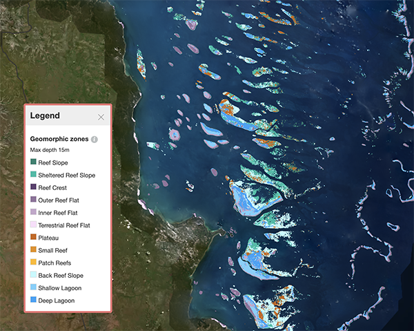
Image above left: Geomorphic Map, Great Barrier Reef. Geomorphic maps communicate the seascape or structure of the ocean floor. There are a total of 12 geomorphic classes identified on the Allen Coral Atlas. Photo credit: Allen Coral Atlas.
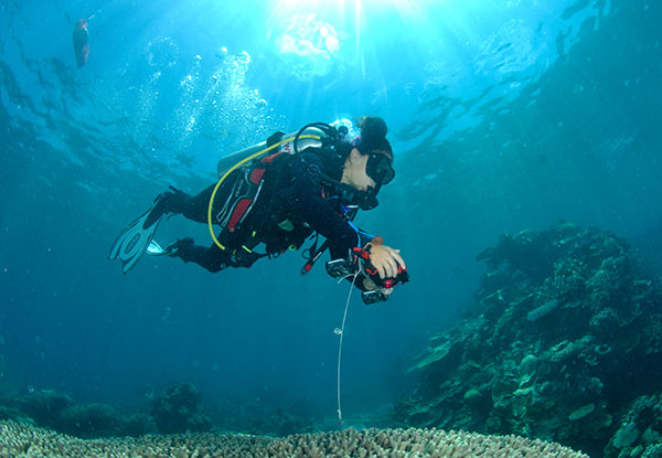
Image above right: Underwater data collection - Dr Alexandra Ordonez Alvarez from The University of Queensland collects georeferenced data in Heron Reef. Photo credit: Chris Roelfsema.
To find out more about Dr Roelfsema's work on the Atlas, read this Research Impact feature.
Media: Dr Chris Roelfsema, c.roelfsema@uq.edu.au, +61 (0)400 207 401; Dominic Jarvis, dominic.jarvis@uq.edu.au, +61 (0)413 334 924.
.jpg)


 and Dr Lulit Habte Ekubatsion at UQ's School of Civil Engineering Concrete Laboratory. Credit: Global Centre for Mineral Security (GCMS).")


