A picture is worth considerably more than a thousand words to marine scientists working on the Catlin Seaview Survey, as they study more than 500,000 images in research to improve coral reef health.
Researchers from The University of Queensland are analysing 360-degree underwater images to perform a global marine environment health check.
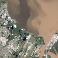
The images, captured across 350 dive-hours as part of the Catlin Seaview Survey, contribute to the Catlin Global Reef Record, a unique coral reef ecosystem global database and online research tool.
UQ Global Change Institute’s Dr Manuel Gonzalez-Rivero said analysis of the images was crucial to understanding coral reef ecology and would inform science-based conservation recommendations and decisions.
“We have more than half a million accurately GPS-located underwater images from 20 countries across 662km of coral reef,” he said.
“Imagine what that can tell us.
“Our understanding of the natural world around us and our ability to protect it is greatly enhanced when we can share in its beauty up close and accurately monitor what is happening to it.”
He said cutting-edge technology such as automated image recognition software meant the images could be collected and accurately analysed 30-times faster than previously possible.
“What can now be achieved in 12 months would have taken 30 years using traditional methods of collection and analysis,” he said.
“The technology matches detailed underwater surveys with satellite data, enabling GCI researchers to study larger areas, up to 100, 200 or even 300 kilometres squared.
“Satellites provide additional information, such as ocean temperature and the locations of regional coral bleaching events, offering a clearer picture of global coral reef health.”
Automated image recognition software is being used to classify habitats, to analyse coral reef coverage, and to study the three-dimensional structure of coral reefs.
“Through GCI’s strong partnerships with Scripps Institution of Oceanography at UC San Diego and the University of Sydney, we are analysing the images in record time,” Dr Gonzalez-Rivero said.
Dr Gonzalez-Rivero’s work is published in Aquatic Conservation Volume 24.
The Global Change Institute is the leading scientific partner for the Catlin Seaview Survey, an internationally renowned research project sponsored by global insurer Catlin Group Limited and managed by Australian not-for-profit Underwater Earth.
Media: GCI Communications and Engagement Officer Rachael Hazell, +61 7 3443 33150, +61 (0) 415814529, r.hazell@uq.edu.au or GCI Postdoctoral Fellow Dr Manuel Gonzalez-Rivero, +61 7 3365 3452, m.gonzalezrivero@uq.edu.au.
Through collaborations with the Catlin Seaview Survey, Scripps Institution of Oceanography at UC San Diego, Sydney Institute of Marine Science, the University of Sydney, the University of California, University of Berkeley, the International Union for Conservation of Nature (IUCN), Google and others, the Global Change Institute is creating strong partnerships with academic institutions and organisations globally to enhance our understanding of coral reef health around the world.
High resolution photographs are available on request.